9+ Best Motorcycle Road Trips in the US [Real Bikers’ Bucket List]
4.10 million miles.
(That’s 6.6 million kilometers if that’s how you prefer it.)
This is how long the entire U.S. road network is. Still think you can blaze them all, you two-wheeled road tripper?
Roads are too long and life too short. But that’s why we’re here today, to guide you towards the 10 best motorcycle rides across America – East and West, North and South.
We’ve asked help from other motorcycle fiends and experts, so they chimed in for this comprehensive compilation of both well-known and lesser-known motorcycle rides through the luscious mountains, scorching deserts and barren wastelands, past the shrubs and grasslands and cacti and lakes.
Buckle up! (And get ready for LOTS of sores and wiping dead bugs off your helmet.) 3, 2, 1…
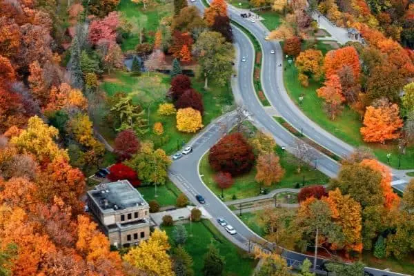
1. Tunnel of Trees, Michigan
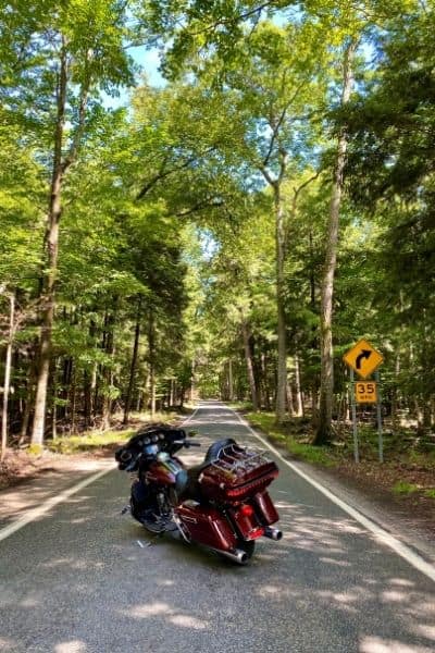
With its thick roof of intertwined hardwood branches, Tunnel of Trees on M-119 is a spectacular forest road, especially suitable for motorcyclists and bicycle riders.
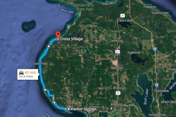
Our fellow rider, Ohio-based travel writer and founder of the blog OhioGirlTravels, Heather Rader, started her journey south in Harbor Springs and rode north to Cross Village.
“Made a pit stop to stretch our legs, eat a freshly made cookie, sip on a glass-bottled Coke and admire the red building of the Good Hart General Store,” Heather says. They ate lunch at the Legs Inn, a rustic lodge restaurant with a view of Lake Michigan, in Cross Village. “After lunch, we ventured south again to admire the Tunnel of Trees once again. I would suggest riding the Tunnel of Trees in the summer or fall and on a weekday for less crowds.”
Pro Tip
A 20-something-mile road could very easily be too short for you. But you can easily double it by taking the east via W Levering Rd, and then US-31 N to get to the Mackinac Bridge!
This is not the first time I’ve heard that this road makes for one of the best motorcycle road trips in the US. If you’re planning for a motorcycle date, this road could be a perfect pick in the fall, with all the colors!
| Route Name | Tunnel of Trees on M-119 |
| Length | 20.4 miles |
| About | A quick, enjoyable ride through the forest tunnel along the Lake Michigan’s shore. Best to do in the fall! |
| Difficulty | Beginner |
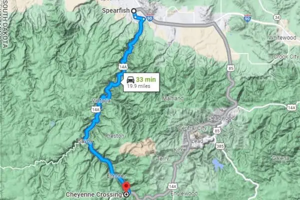
2. Spearfish Canyon, South Dakota
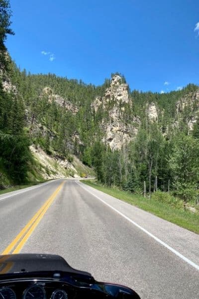
Off to the west, and there’s another scenic road stretching from Spearfish to Cheyenne Crossing – the Spearfish Canyon.
“Sweeping curves winding alongside Spearfish Creek, thousand foot towering limestone cliffs and waterfalls are just a few of the notable scenic views,” Heather of OhioGirlTravels recounts. “A few spots to stretch your legs are Bridal Veil Falls and Roughlock Falls, have breakfast or lunch at Cheyenne Crossing’s Stage Stop Cafe or at Latchstring Restaurant at Spearfish Canyon Lodge.”
If you’re all eyes for this ride, Heather recommends you to choose summer or fall.
Now, the route is littered with twists and turns, plus the magnificent view can easily divert your eye from the road. So I’d suggest you to choose an easier road if you’re a newbie!
Tip for Beginners
If you’re determined to give it a shot as a newbie, be sure to choose early morning and midweek. Those are the times when the route is at its quietest!
A cruise through the canyon takes about 2 hours, but you’ll want to allot a bit more to admire the rock formations and waterfalls! There’s plenty of photo ops too, with all the places where you can pull off.
| Route Name | Spearfish Canyon |
| Length | 19.9 miles |
| About | A short, pretty challenging and extremely rewarding route! The road is good quality, but there are many curves. |
| Difficulty | Intermediate/Advanced |
3. Going-to-the-Sun Road Through the Rockies, Montana
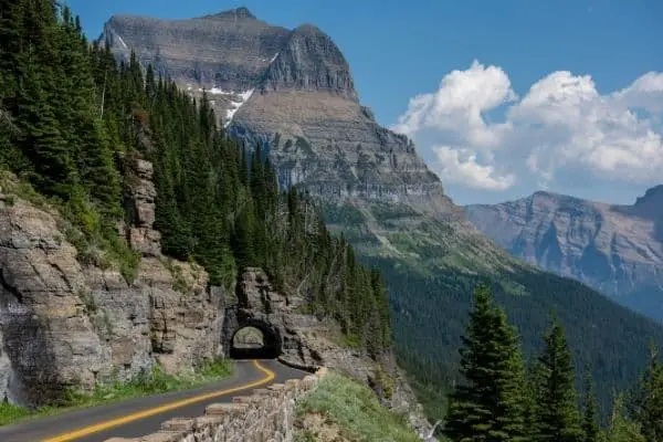
For those of you who aren’t familiar with this road, let’s just say it passes through the Glacier National Park. So yes, you should get your camera ready!
“The road is situated in a region rich in breathtaking mountain sceneries and an overall amusing landscape,” says Alex Wan, motorcycle enthusiast and co-founder of Vinpit, who pitched this motorcycle road trip to us. “Going-to-the-Sun Road gets nature lovers like me a chance to explore the beauty of nature. Think of having a view of the Glacier National Park, taking a tour at the Logan Pass, etc. With a pair of binoculars, summers can’t get better.”
The landscapes are fabulous alright, but make sure to pick your weather carefully or this otherworldly road might quickly turn into a nightmare well before you reach the sun. And when you’re a fragile little heap of bones and muscles in a biker’s armor, it can even become a death trap. The road gets closed for cars whenever the weather doesn’t cooperate. Take a look at this site for more info!
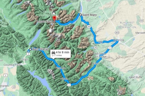
| Route Name | Going-to-the-Sun Road |
| Length | 235 miles |
| About | Not for the faint of heart, both in terms of beauty and difficulty! |
| Difficulty | Advanced |
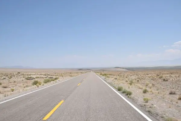
4. Route 66 Desert Ride
Down to the desert!
This list just wouldn’t be complete without embarking on the American rider’s dream.
But there’s a twist. While cruising for weeks along the full Route 66 from Chicago all the way to Santa Monica definitely is on my bucket list, I wouldn’t take the all-in approach my first time.
Instead, I’d “only” cross the desert. That’s some 1,350 miles under the scorching sun!
But if you’re wondering where to make the stops, a fellow rider offers an invaluable tip.
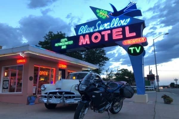
Tucumcari, New Mexico is a very small town, but they don’t call it “The Heart of Route 66” for no reason. The road goes straight through the town. A perfect spot to rest the weary eyes after basking in those golden sunsets!
The place has all the iconography of a rough and rugged little spot in the American desert, with just a few thousand inhabitants and a bunch of abandoned (or seemingly abandoned!) diners and inns and motels. History has it that the place was rich with gunfights. Hell, it was even called Six Shooter Siding some 100 years ago, while it was still just a camp.
Pro Tip
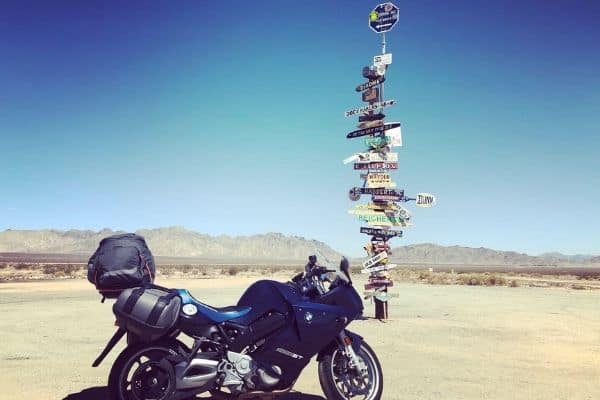
If you’re set on completing the Route 66 all the way to Santa Monica and haven’t had enough riding, a 382-mile ride north to Tonopah, Nevada could be a great idea. To find out why, scroll down to my pick #7!
Andrew Beattie, founder of The Motelorcycle Project and author of Sleeping Around in America: Revisiting the Roadside Motel, whose recommendation this is, likes to stay in “probably the most photographed motel in America”, The Blue Swallow. “But it isn’t the only one in town. Here you will find the Roadrunner Lodge, The Motel Safari, Route 66 Motel and more – all perfectly preserved, complete with magic finger vibrating beds to bring people off the interstate and back on to Route 66,” Andrew tells me.
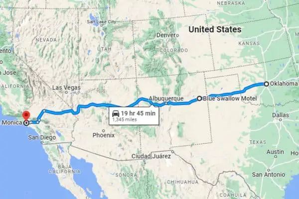
| Route Name | Route 66 from Oklahoma City to Santa Monica |
| Length | 1,345 miles |
| About | You can make it as short or as long as you want, but make sure to stop in Tucumcari! |
| Difficulty | Beginner/Intermediate |
5. Through the Desert to Twentynine Palms, California
If you take Route 40 or Interstate 10 and are heading to California, be sure to plan for a stop at 29 Palms, a charming little city that’s one of the mouths into Joshua Tree National Park.
It’s also close to an undeveloped section of the Mother Road – in other words, it’s a Mecca for motorcyclists!
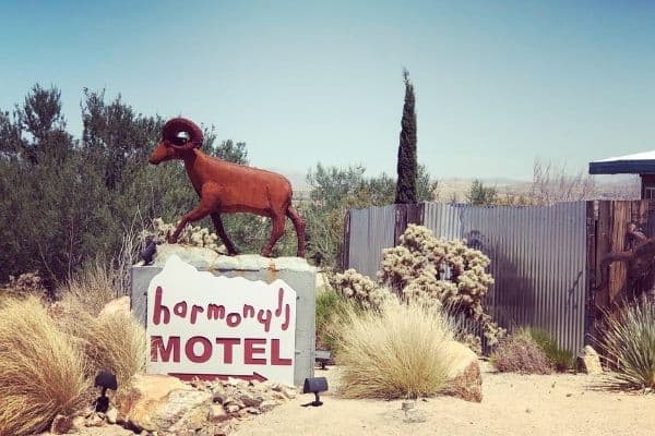
Andrew from The Motelorcycle, who recommended us this stop, has visited and stayed in the Harmony Motel, just outside of the national park. “The motel is famous for the incredible cover art photo of U2 album The Joshua Tree,” Andrew recounts. “Yes, Bono stayed there and you too can stay in his room. But the story gets even cooler. The owner is a black immigrant woman from South Africa who purchased the motel some years back. She fled South Africa following the end of apartheid where the country devolved into chaos. What ties the two stories together is that U2 is known for voicing political protest in their music. Their hit single from the Joshua Tree was Streets With No Name and on the ‘B’ side – a song called Silver and Gold – a song about apartheid in South Africa.”
Fans of U2 and pacifism, rejoice. But don’t forget that blazing through the subtropical Mojave desert can be a hellish experience, with all the hot gusts of wind and the scorching asphalt heat.
Oh! In case you were wondering, there aren’t 29 palms anywhere in the town.
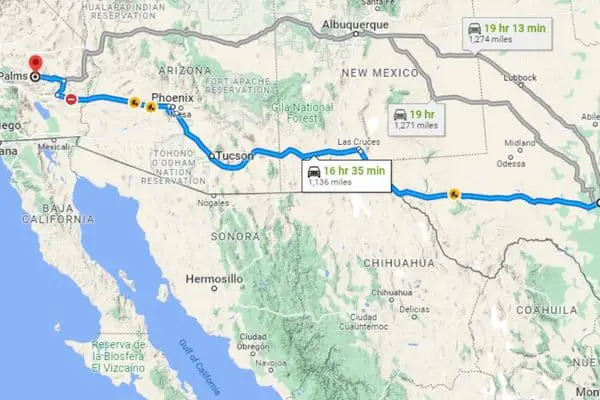
| Route Name | Interstate 10 to Twentynine Palms, CA |
| Length | 1,136 miles |
| About | If you’re heading from Texas or New Mexico into California, make sure to make a stop at 29 Palms! Hint: U2 fans will enjoy. |
| Difficulty | Beginner/Intermediate |
6. Monument Valley, Arizona-Utah
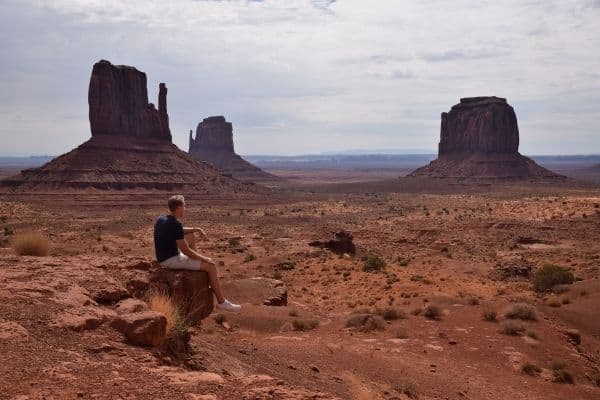
This incredible scenery on the Navajo land isn’t just famous because of John Ford, Dennis Hopper, Robert Zemeckis and other notable fans. It’s also the staple and icon of the popular Wild West imagery. So how can a biker resist its charms?
Christian Monson, editor at SimplyMotorcycle, recommends spending the night in a cabin to get the most of the sunrise protruding from beneath the buttes. But there are things to keep in mind. “Just one note: If you want to drive the dirt-road loop that wraps around all the ‘monuments,’ there’s technically a sign that says you can’t take motorcycles. We asked and they let us anyway, but you might not have the same luck.”
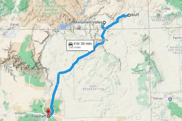
| Route Name | Monument Valley |
| Length | 245 miles |
| About | Another desert road through iconic scenery of the Navajo land! |
| Difficulty | Intermediate |
7. Salt Lake City to Tonopah, Nevada
Our biker pal Christian discovered this tiny little oasis in the middle of the desert during his month-long trip around the US Southwest with his wife. They’d never heard of it before and only decided to give it a try after a long cruising session on their way to Salt Lake City.
Are you afraid of clowns? Tonopah is known for its “Clown Motel” that owes some of its spookiness to the nearby cemetery, but Paul and his biker companion decided they weren’t really into clowns. “We settled on the Mizpah Hotel right in downtown, which instead of horror went with a Western theme. The entire town itself feels like you’ve been transported back to the 1890s, and it’s a quiet place to relax and take in your trip.”
Small-town America indeed! David Lynch fans would be delighted. I know my biker bucket list just got a new entry.
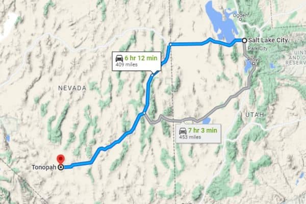
| Route Name | Salt Lake City to Tonopah, Nevada |
| Length | 409 miles |
| About | If it sounds as a road to nowhere, it’s because it is! Just kidding. Tonopah is a little place that looks as if frozen in time! |
| Difficulty | Beginner/Intermediate |
8. Pacific Coast Highway, Carmel to Morro Bay, California
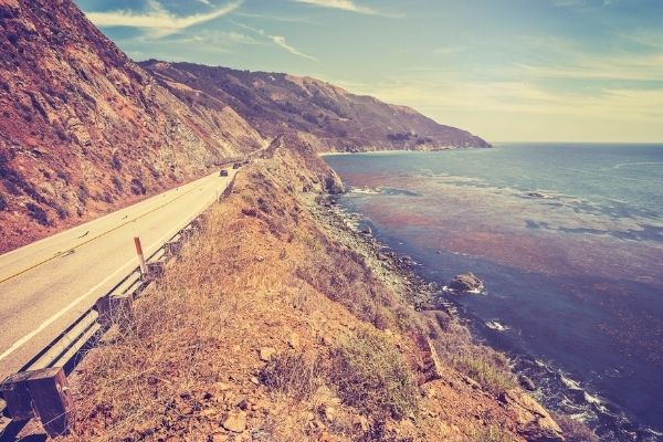
Another scenic roadway from one bay to another, under the sunny California skies. This one’s a favorite to Olivia Tan, biker and co-founder of CocoFax.
“It offers a smorgasbord of treats: crashing surf, towering redwood forests, seal-dotted beaches, and enough curves to keep you content end to end,” Olivia says. “This cliff-hugging ribbon stretches 120 miles and has frequent turnouts for enjoying the stellar views. It’s enough to whet your appetite for more, and that’s no problem.”
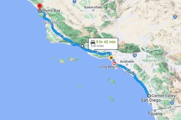
| Route Name | Carmel to Morro Bay, California |
| Length | 324 miles |
| About | If you’re one to relish sounds of the ocean intermingling with the roar of your engine, this route is perfect for you! |
| Difficulty | Beginner/Intermediate |
9. As Far North as North Goes: Fairbanks to Prudhoe Bay, Alaska
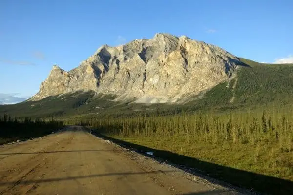
An extraordinary suggestion comes from Tranquilo Jonny, a hardy adventurer who has whooshed over the whole world on his two wheels. His is a story of a guy who spent 15 months riding from New York to Deadhorse, Alaska, then all the way down to Ushuaia, the southernmost tip of Argentina!
“Alaska was mind blowing. Around each corner was yet another breathtaking vista, glacier after glacier. Watch for the trucks on the Dalton Highway. They have the pedal to the metal and don’t give way. They throw up rocks which can do serious damage to you and the bike. And don’t fall off the road – it’s built on top of the permafrost with some serious drops on each side,” Jonny warns. And if there’s ANY damage done to you or the bike, getting help can take hours, even days.
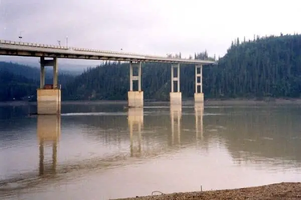
He then splattered down 500 miles of dirt roads, and then humped the Yukon River Bridge made out of wooden planks that you’ll want to be careful with when the weather isn’t dry. Above the Arctic Circle, Jonny’s first stop was Coldfoot Camp, which is a humble truck inn to warm up the bones, get some food in the belly and spend the night.
Except that there was a poster of a black bear on the door. A piece of Arctic décor or a warning?
250 miles later, he passed the last tree and reached the Continental Divide, where rivers to the north empty into the Arctic Ocean, and rivers to the south into the Bering Sea. “If you reckon you are doing something extraordinary, forget it! There’s always someone else doing something more extreme,” Jonny says. “Seeing a man on a bicycle, we stopped to chat. He had been having problems with bears and had to camp on the side of the road at night.”
The bicycle guy told him a joke. What do bears call a man on a bicycle? Meals on wheels. And what about a motorcyclist? Fast food!
Bears aren’t the only wild animals Jonny had to keep in mind while riding. Moose, caribou, musk ox… Freedom comes at a price. And when you’re this far north, the price includes a risk of unpleasant encounters.
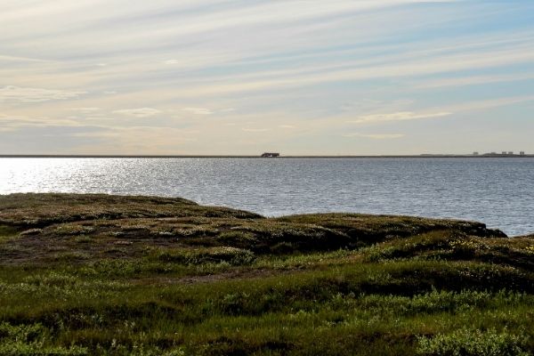
Having reached Prudhoe Bay (and paid $60 to get a bus ride when the road ended), Jonny had his fill of excitement. “Security is tight up here, but to dip my toes into the Arctic Ocean, to walk along a beach covered in bear paw prints, to watch a family of arctic foxes! 7000 miles over 4 months – well I did have a big smile. And I was ‘only’ facing another 20,000 miles or so left to reach Ushaia and the Drake Passage.”
Pro Tip
If you should dare to ride these roads, heed Jonny’s advice and be super careful. “Trying to keep the bike black side up is horrendous due to the construction crew with their graders and water tankers. The graders loosen the gravel, so you have to crisscross piles of deep, loose gravel. That’s a nightmare on its own, but what’s even worse is that, having regraded the road, they then water it to compact it. Man, that is like being on ice!”
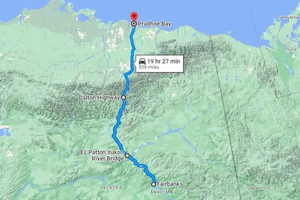
| Route Name | Fairbanks to Prudhoe Bay, Alaska |
| Length | 838 miles |
| About | A majestic adventure that can easily turn into a nightmare if you’re not extremely resourceful! |
| Difficulty | Advanced |
If you’re after northern adventures, make sure to also consider conquering the Norwegian fjords in Europe!
10. Bonus: Niagara Parkway, Canada
‘Nuff with the wastelands, I hear you! Give me some luscious greenery and the cooler (but not freezing) breeze of the North.
So let the colors sing!
Niagara Parkway in Canada isn’t just green and scenic, though. It’s also one of the most motorcycle-friendly roads on the continent. Our biker friend Andrew Beattie traversed it and stayed in the Cadillac Motel. The unique mix of French charm and wild Las Vegasian hubbub wasn’t lost on him.
“There are wineries all around and a ton of fun with so many attractions on Clifton Hill. And the Cadillac Motel is an ode to the great vehicle. Every room is adorned with a classic Cadillac including the ones Elvis and Marilyn Monroe made famous. Don’t let the name fool you – the owners love to welcome motorcycle travelers!”
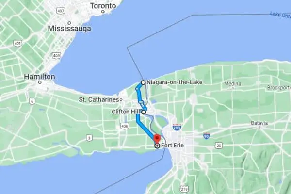
| Route Name | Niagara Parkway, Canada |
| Length | 55 km (34 miles) |
| About | One of the shortest routes on our list, it’s very romantic and peppered with wineries. |
| Difficulty | Beginner |